


GMS NX
Geomechanical survey of rock-mass discontinuities in the browser — from the compass-and-clinometer field reading to the 2D and 3D stereonet, the Fisher statistics and the Markland kinematic test, following the ISRM recommendations. With AI-assisted import, a smartphone compass companion and a ready-to-deliver Word report.
What it does
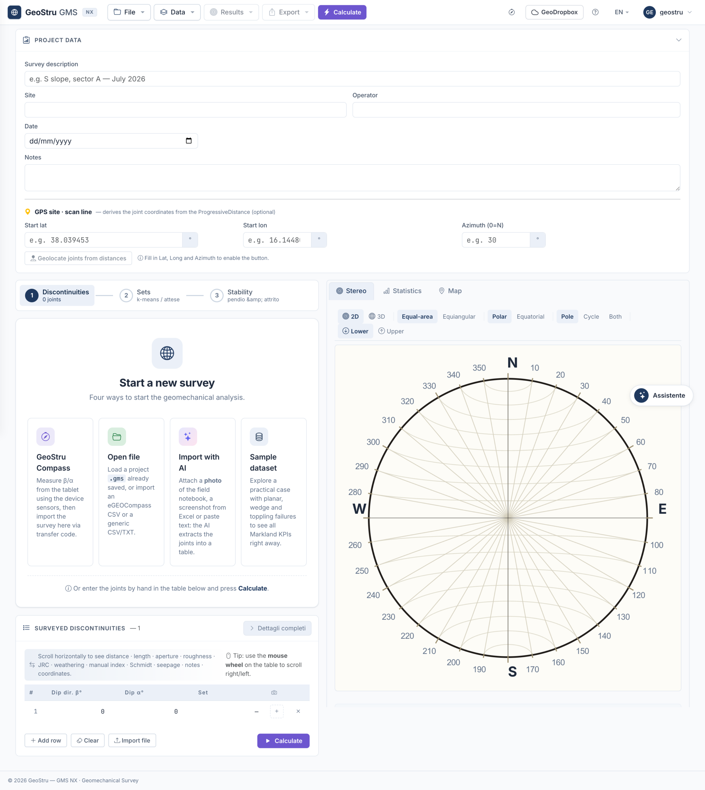
GMS NX is the web generation of GeoStru's program for geo-structural surveys of discontinuities in rock masses — the compass-and-clinometer method of the ISRM Suggested Methods, brought into the browser and enriched with a 3D stereonet, a native map, AI import and a smartphone compass.
ISRM field survey — orientation and the full set of ISRM descriptive parameters — aperture, spacing, persistence, roughness — recorded per discontinuity, following the ISRM Suggested Methods.
2D and 3D stereonet — equal-area Schmidt–Lambert or equal-angle Wulff projection, and a rotatable 3D sphere with poles, great circles and wedges.
Joint sets and statistics — automatic spherical k-means clustering and Fisher statistics — concentration parameter k, confidence cone α₉₅ and mean resultant R̂.
Markland kinematic test — planar sliding, wedge and toppling checks against the slope face, with an operational verdict and suggested countermeasures.
AI import and Compass NX — extract orientations from free text, PDFs or photos, and survey in the field with the Compass NX smartphone app.
Deliverables — a structured Word report on the ISRM 15-column scheme, plus DXF, CSV, SVG and PNG; projects autosaved to the cloud.
Stereonet and statistics
Every measurement becomes a point on the sphere, and the joint sets emerge from statistics you can inspect.
Projections — equal-area (Schmidt–Lambert) or equal-angle (Wulff), polar or equatorial, upper or lower hemisphere, toggled live.
Great circles and poles — mean-plane great circles per joint set, with a Pole / Great circle / Both toggle.
Fisher statistics — the concentration parameter k, the confidence cone α₉₅ and the magnitude of the resultant R̂, with 1-NN spherical assignment to sets.
Distributions — a dip-direction rose, Denness isodensity over 100 spherical cells and ISRM modal histograms of aperture, spacing and persistence.
Markland kinematic analysis
The kinematic test tells you which failure modes the slope geometry allows — and what to do about them.
Failure modes — planar sliding and wedge failure per Hoek & Bray (1981) and toppling per Goodman & Bray (1976), checked against the slope face and the friction angle.
Operational verdict — the critical kinematisms are counted and flagged, with the reminder that Markland is necessary but not sufficient — it confirms geometric compatibility, not stability.
Countermeasures — suggested stabilisation works for the preliminary design — scaling, rock bolting, anchors, rockfall nets, reinforced shotcrete and sub-horizontal drains.
Field survey, Compass NX and import
The orientations can reach GMS NX from the field, from a file or from a photo.
Compass NX — an installable smartphone app (iOS and Android, the evolution of eGeoCompass) with the native compass and clinometer, GPS, photo and voice note per joint; transferred to the desktop with a six-digit code — no Wi-Fi and no shared account.
AI import — automatic extraction of dip and dip-direction from unstructured text, legacy PDF reports or heterogeneous tables.
3D point cloud — import .PLY, .OBJ or .XYZ from drone photogrammetry or LiDAR, with RANSAC extraction of the discontinuity planes.
Native map — OpenStreetMap, topographic and satellite backgrounds, with each joint in decimal lat/lon and UTM coordinates.
How it works
A guided flow takes you from the field reading to the delivered report.
1 · Survey — read each discontinuity with the compass and clinometer — or with Compass NX — and record its ISRM parameters.
2 · Import — bring the data in from Compass NX, a file (.gms, .pol, .csv), AI import or a 3D point cloud.
3 · Joint sets — cluster the orientations into sets with spherical k-means and review the Fisher statistics.
4 · Stereonet — inspect the poles, great circles and distributions in 2D and in the 3D sphere.
5 · Kinematic test — run the Markland analysis against the slope face and friction angle for planar, wedge and toppling modes.
6 · Report — export the Word report on the ISRM 15-column scheme, with the stereonets, roses and histograms as high-resolution figures.
Inputs and outputs
What you enter
Orientations — dip and dip direction per discontinuity, plus the ISRM descriptive parameters.
Slope and rock — the slope face orientation and the friction angle for the kinematic test.
Sources — manual entry, Compass NX, .gms/.pol/.csv files, AI import or a 3D point cloud.
What you get
Stereonets — 2D and 3D projections with poles, great circles and wedges.
Statistics — joint sets with Fisher k, α₉₅ and R̂, and the ISRM distributions.
Kinematic verdict — the critical planar, wedge and toppling modes with suggested countermeasures.
Deliverables — a Word report on the ISRM 15-column scheme, plus DXF, CSV, SVG and PNG, cloud-autosaved.
Who it's for
Applied geologists · Geotechnical and geomechanical engineers · Rock-slope consolidation designers · Consultancies and construction firms · Universities. GMS NX is for anyone who surveys rock-mass discontinuities and assesses rock-slope stability — along excavation faces, slopes, tunnels and coastal cliffs — and wants the whole workflow, from compass to report, in one web app.
Why it's different
Runs in the browser — no installs, no hardware keys, projects autosaved to the cloud.
A rotatable 3D stereonet with poles, great circles, wedges and the slope plane in perspective.
AI import that reads orientations from free text, PDFs and photos.
Compass NX on the phone — GPS, photo and voice note, transferred by a six-digit code.
A native map (OSM, topographic, satellite) with UTM and lat/lon to six decimals.
Point-cloud import from LiDAR and photogrammetry, with plane extraction in 3D.
The Markland verdict paired with typical stabilisation works for the preliminary design.
Frequently asked questions
How many measurements do I need?
At least about 30 orientations for meaningful statistics, ideally 50–150 per face.
The Markland banner is green but the slope looks unstable — why?
Markland is necessary but not sufficient: it only confirms that the geometry is compatible with a failure mode, not that the slope is stable.
Which files can I import?
GMS files (.gms, .pol), .csv and eGeoCompass data, and 3D point clouds as .ply (ASCII), .obj or .xyz — convert .las in CloudCompare first.
Can I survey from a phone?
Yes, with Compass NX on Chrome for Android or Safari on iOS 13+; it uses the phone's compass and clinometer over HTTPS.
How is the phone data transferred to the PC?
With a six-digit code valid for 30 days — no Wi-Fi and no shared account needed.
Is GMS NX free?
It is part of the GeoStru NX suite with a freemium plan: free unlimited access, with premium features such as AI import on subscription.
Ready to start with GMS NX?
Choose your plan and start using GMS NX today. Runs in the browser, always up to date, no installation required.